A practical guide to bird watching in Sonoma County, California
(Unless otherwise indicated, all phone numbers are in the 707 area code)
A practical guide to bird watching in Sonoma County, California
(Unless otherwise indicated, all phone numbers are in the 707 area code)

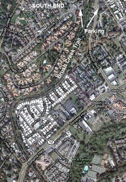
Brush Creek Trail, Santa Rosa, CA 95409
Location aliases: Usually referred to simply as Brush Creek, or Brush Creek Trail. Confusingly, the entrance to the middle section of the trail is marked with signs for Austin Creek where the two creeks merge.
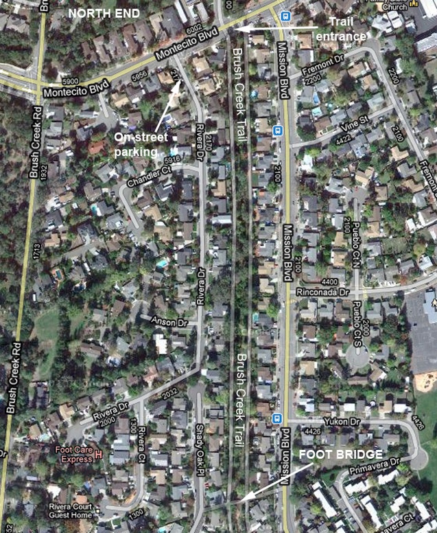
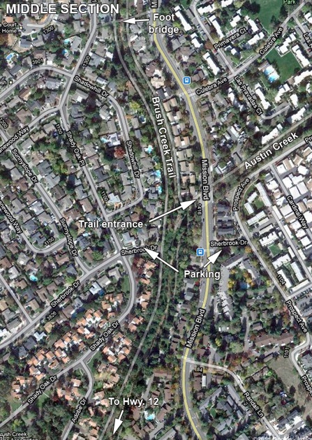
Location: An extended trail for bicycles and pedestrians that runs along both sides of Brush Creek in Santa Rosa, stretching from Montecito Blvd. in the north to Hwy. 12 and beyond to the south.
GPS address: 2170 Rivera Dr., Santa Rosa, CA 95409 will be near parking at the north end of the trail--the Montecito Blvd. end. 3909 Sherbrook Dr. will put you at the end of that street, on the west side of the trails and the creek. 1441 Mission Blvd. will bring you close to the intersection of Mission Blvd. and Sherbrook Dr. for parking on the east side of the trails and creek. The entrance to the trails on the east at Sherbrook Dr. is close to 1703 Mission Blvd. (about 100 yards north of Sherbrook Dr.).
GPS Coordinates: Coordinates of 38 28 17N, 122 40 42W will take you to a point near the intersection of Mission Blvd. and Rivera Dr. The dead end of Sherbrook Dr. on the west side of the creek and trails is at 38 27 48N, 122 40 37W. The intersection of Sherbrook Dr. and Mission Blvd. (on the east side of the creek and trails) is at 38 27 48N, 122 40 32W.
Habitats: A thin strip of riparian woods (mature evergreens, mature oaks), creekside brush, residential areas along Brush Creek and Austin Creek.
Typical Species: Good habitat for various woodland species and species that like waterways. Mallard, Turkey Vulture, Anna's Hummingbird, Belted Kingfisher, Acorn Woodpecker, Downy Woodpecker, Hairy Woodpecker, Nuttall’s Woodpecker, Black Phoebe, Western Scrub-jay, American Crow, Raven, Bushtits, Bewick's Wren, European Starling, Cedar Waxwing, Oak Titmouse, Chestnut-backed Chickadee, White-breasted Nuthatch, Ruby-crowned Kinglet, Hermit Thrush, Yellow-rumped Warbler, Townsend’s Warbler, Orange-crowned Warbler, Wilson’s Warbler, Spotted Towhee, California Towhee, Song Sparrow, White-crowned Sparrow, Golden-crowned Sparrow, Dark-eyed Junco, House Finch, Pine Siskin, Lesser Goldfinch, American Goldfinch.
Restroom facilities: None along the trail. Restaurants listed below probably offer the closest restrooms.
Restaurants nearby: Oliver's Market at 560 Montecito Center, on Montecito Blvd., Santa Rosa 95409 has deli sandwiches and is probably the closest place to find food at the Montecito end of the trail. At the Hwy 12 end is Betty's Fish and Chips (4060 Sonoma Highway--Hwy 12 by another name, 539-0899), which offers a good variety of choices. About a half mile to the west on Hwy. 12 is what locals will refer to as the 4th St. Safeway, which also has deli sandwiches and other food. East West Café at 557 Summerfield Rd. (546-6142) serves good Mediterranean-influenced meals with many vegetarian choices. Lepe's Taqueria at 4323 Montgomery Dr. (538-8891) offers very good informal Mexican. These last two may be good choices if you are heading to Howarth Park (Lake Ralphine) or Spring Lake from Brush Creek. They will be on the way.
Nearby attractions: Extensive hiking, horseback riding, and mountain biking trails at Annadel State Park. Nearby Spring Lake offers swimming at the lagoon during the summer months (with lifeguards). Canoes, kayaks, other small (non-motorized) boats and paddle boats allowed on the main lake. Fishing (largemouth bass, sunfish, catfish; California fishing license required for those 16 and older). Hiking trails. Picnic areas. Campgrounds open seven days a week from May 1 through September 30, otherwise weekends and holidays only (539-8092 for information). Neighboring Howarth Park offers play areas for children, paddle-boating at Lake Ralphine; summer children's activities include a carousel, a miniature steam engine kids and adults can ride on, petting zoo, pony riding. Public tennis courts. Continuing beyond Howarth Park on Summerfield Rd. and then out Montgomery Dr. to the right will connect you with Highway 12 (also known as Sonoma Highway), which leads to the Sonoma Valley wine country with many excellent wineries. Bennett Valley Golf Club is at 3330 Yulupa Ave. (528-3673). Public tennis courts next door to the golf course at Galvin Park. There are one or two wineries also further out Bennett Valley Rd. beyond the golf course, the best known being Matanzas Creek Winery (6097 Bennett Valley Rd., 528-6464)--worth a visit for its lavender fields, usually in bloom in June.
Related bird watching spots: All of the Santa Rosa locations listed on the site here are within easy striking distance, but the closest will be Lake Ralphine, Spring Lake, Arroyo Sierra Dr., and Strawberry School Park.
Notes: Watch for cyclists. Road noise is present all along the trail, which can be frustrating, but there are plenty of birds around. Note that a full circuit of the trail is quite long. There are only one or two places to cross the creek and loop back to a given starting point. See maps.
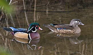
The birds in the photo: Wood Ducks, Brush Creek, February 4, 2011
All photos by the author, unless otherwise indicated
Maps by Google Maps
© Colin Talcroft, 2009, 2010, 2011.
Unless noted, all photos by the author. If you would like to use one of my images, please ask for permission for non-commercial use with proper credit or commercial use with proper compensation.